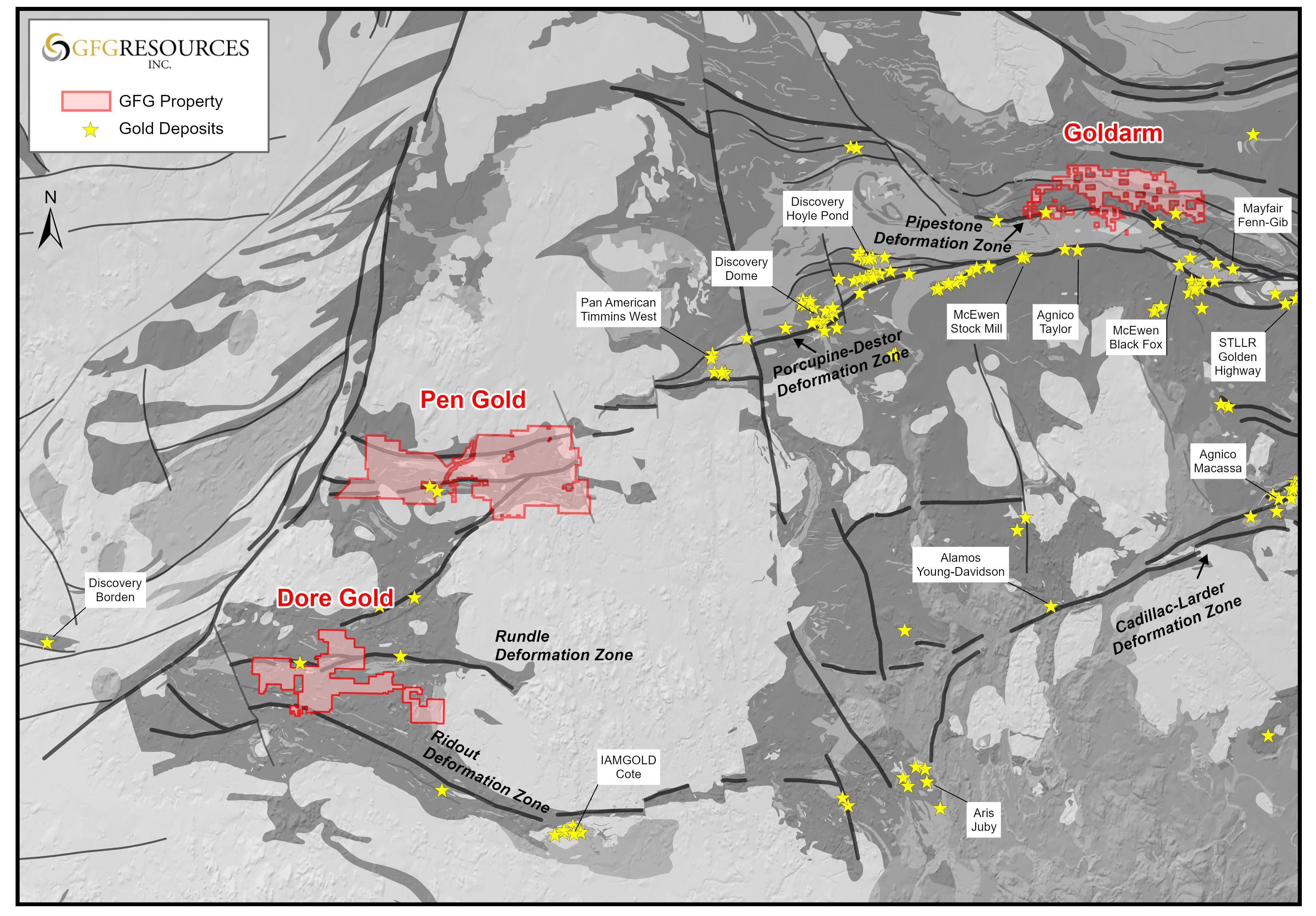
• TSX-V: GFG
  • $0.15+0.00
  • Volume40,000
  • Range$0.15$0.15
  • 52 Week$0.13$0.21
  • Open$0.15
View more details
  • TSX-V: GFG
  • $0.15+0.00
  • Volume40,000
  • Range$0.15$0.15
  • 52 Week$0.13$0.21
  • Open$0.15
View more details

GFG Gold Projects in the Timmins Gold District

Overview

In Ontario, GFG Resources Inc. operates three district-scale gold projects—Goldarm, Pen, and Doré—each representing large, highly prospective land packages within the prolific Timmins Gold District. These projects share key geological characteristics with many of the deposits that have collectively produced over 70 million ounces of gold in the camp, positioning GFG to capitalize on one of the world’s most established gold jurisdictions.

Goldarm Property Overview

The Goldarm Property is located immediately east of Timmins, Ontario, and encompasses over 200 square kilometres, including approximately 30 kilometres of the highly prospective Pipestone Fault corridor.

Through a combination of earn-in agreements, strategic acquisitions, and systematic staking, GFG has successfully consolidated a dominant land position in this emerging extension of the Timmins Gold Camp.

The property is anchored by several key assets, including the Montclerg Gold Project, the WWCC Property, and the Aljo Gold Project—each contributing to a growing pipeline of discovery opportunities. In addition, GFG has expanded its footprint through the staking of more than 6,500 hectares of contiguous ground adjacent to the WWCC and Aljo areas, further enhancing district-scale exploration potential.

Pen Gold Project Overview

The Pen Gold Project is located approximately 50 kilometres southwest of Timmins, Ontario, within a well-established mining corridor. The project spans roughly 475 square kilometres and occupies a strategic position between Discovery Silver Corp.’s Borden Gold Project and Pan American Silver Corp.’s Timmins West Mine.

Pen covers an approximately 55-kilometre-long section of Archean greenstone that hosts the interpreted western extension of the Porcupine-Destor Fault Zone (PDFZ)—a major structural corridor associated with numerous gold deposits in the Timmins camp. This geological setting, combined with the project’s scale and location, supports significant discovery potential across multiple target areas.

Doré Gold Project Overview

The Doré Gold Project is located approximately 40 kilometres east of Discovery Silver Corp.’s Borden Gold Project and 30 kilometres northwest of IAMGOLD Corporation’s Côté Gold Project in Ontario.

Covering approximately 212 square kilometres, the Doré Project encompasses a 12-kilometre-long segment of Archean greenstone within the underexplored Swayze Greenstone Belt. The project’s favorable geological setting, combined with its proximity to major gold deposits and infrastructure, positions it as a compelling exploration opportunity within GFG’s broader portfolio.

Property Location Map


Montclerg Gold Project

Overview

The Montclerg Gold Project is located 48 km east of the prolific Timmins Gold Camp and is surrounded by multiple current and historic gold mines. The Project consists of five patented mining claims and 110 unpatented mining claims that cover 10 km of the highly prospective Pipestone Deformation Zone which hosts multiple gold deposits and mines in one of the most prolific gold districts in the world.

The Montclerg Gold Project overlaps the Pipestone Deformation Zone, a major northern splay of the Porcupine Destor Deformation Zone (“PDFZ”), approximately 8.5 km east of Grace Gold’s Clavos gold deposit and 37 km west of Mayfair Resources’ Fen-Gibb gold deposit. The two gold prospects at the Montclerg Gold Project, MC and CX, occur north and south of the Pipestone Deformation Zone, respectively, and are associated with east-northeast trending fault zones that bisect the metasedimentary, felsic volcanic, mafic volcanic and felsic porphyric rocks of the area.

Property Location

Montclerg Gold Project Overview Map
Geology

TThe Montclerg Gold Project overlaps the Pipestone Deformation Zone, a major northern splay of the Porcupine Destor Deformation Zone (“PDFZ”), approximately 8.5 km east of Grace Gold’s Clavos gold deposit and 37 km west of Mayfair Resources’ Fen-Gibb gold deposit. The two gold prospects at the Montclerg Gold Project, MC and CX, occur north and south of the Pipestone Deformation Zone, respectively, and are associated with east-northeast trending fault zones that bisect the metasedimentary, felsic volcanic, mafic volcanic and felsic porphyric rocks of the area.

Since the discovery of gold at the MC prospect in 1938, and prior to the acquisition of the Project by GFG, a total of 19,730 m were drilled in 96 holes that sporadically test the trend over a 1.5 km strike length. The vast majority of holes, approximately 80, were drilled prior to 1967 and focused on depths of less than 150 m. These historic holes were not sampled completely with only the most intensely veined intervals assayed. Drilling in 2016 demonstrated the existence of up to five separate gold zones at the MC prospect. Well-sampled drill core shows three upper zones with grades and thickness on the order of 1.5 g/t Au over 25.5 m. Two deeper zones were intersected in several drill holes that tested the mafic volcanic footwall deeper than 200 m vertical. The two deeper zones are higher grade and have returned up to 3.28 g/t Au over 2.4 m, 3.69 g/t Au over 7.4 m (including 9.23 g/t Au over 2.2 m) and 6.05 g/t Au over 2.0 m. Broadly spaced drilling indicates this footwall system extends over a strike length of 175 m.

The CX prospect, occurring about 350 m south of the MC prospect, was first drilled in 1987. A total of 4,700 m has been drilled in 23 holes that test portions of the 1.2 km trend to depths of less than 200 m. To date, GFG has not completed any drilling on the CX Prospect. The geology and character of mineralization is analogous to the Clavos gold deposit with the mineralization at CX also occurring in close proximity to a quartz-feldspar porphyry body that intruded along the contact of the metasedimentary and ultramafic rocks within the Pipestone Deformation Zone.

Both the MC and CX prospects have only been drilled sporadically along strike and have only been tested to shallow depths (<200 m vertical). They remain open at depth and along strike. Importantly, the deeper high-grade zones at the MC prospect demonstrate the high prospectivity of the footwall mafic volcanic rocks.

Pen Gold Geology Map July 2018

Pen Gold Project

Overview

The Pen Gold Project, comprised of the West Porcupine and Pen Gold properties, is located 50 kilometres southwest of the prolific gold district and town of Timmins, Ontario and approximately 90 kilometres from Goldcorp’s Borden gold project. The property represents a land package of approximately 445 square kilometres and is situated between Goldcorp’s Borden gold project and the Tahoe Resources’ West Timmins Mine. The property consists of 162 claims and covers a 55-kilometer-long section of Archean greenstone that contains the interpreted western extension of the Porcupine-Destor Fault Zone within the same geological setting that hosts most of the gold deposits found in the Timmins Gold Camp.

Property Location

Pen Gold Project Overview Map July 2018
Geology

The Pen Gold Project is located in the Archean Superior Province of Northern Ontario. The Archean Superior Province is host to a variety of lithologies which range in age from 3.5 Ga to less than 2.76 Ga and form an east-west trending pattern of alternating terranes. It is divided into numerous subprovinces, bounded by linear faults and characterized by differing lithologies, structural/tectonic conditions, ages and metamorphic conditions.

The Abitibi Subprovince, is a volcano-plutonic terrane comprising low metamorphic grade metavolcanic-metasedimentary belts. It contains lithologically diverse metavolcanic rocks with various intrusive suites and to a lesser extent chemical and clastic metasedimentary rocks. The individual greenstone belts within the Subprovince have been intruded, deformed and truncated by felsic batholiths. The east trending Abitibi and Swayze greenstone belts of the Abitibi Subprovince have historically been explored and mined for a variety of commodities.

The Pen Gold Project lies within the Abitibi Subprovince, proximal to its western boundary with the Kapuskasing Structural Zone and the Ivanhoe Lake Cataclastic Zone. The properties are situated in the northern part of the Swayze Greenstone Belt and may be a possible western extension of the Abitibi Greenstone belt. The Pen Gold Project covers the interpreted westward extension of the Porcupine-Destor Fault Zone and is thus highly prospective for gold mineralization.

Pen Gold Geology Map July 2018

Dore Gold Project

Overview

The Dore Gold Project (previously Swayze Gold Project) is located 40 kilometres east of Newmonts’s Borden gold project and 30 kilometres northwest of IAMGOLD’s Cote Lake gold project in Ontario. The land package consists of approximately 212 square kilometres and covers a 12-kilometre-long section of Archean greenstone within the Swayze Greenstone Belt.

Property Location Map

Geology

The Dore Gold Project is located within the Swayze Greenstone Belt that is part of the western extension of the Abitibi Subprovince, a Neo-Archean granitoid-greenstone belt. This greenstone belt is bounded to the west by the Kapuskasing Fault and to the east by the Kenogamissi Batholith. Several major fault systems transect the greenstone belt including the interpreted westward extension of the Porcupine-Destor Deformation Zone and the Ridout Fault.

The Dore Gold Project covers east-west oriented Timiskaming-type volcano-sedimentary rocks that overlie mafic and felsic volcanic packages along the Rundle Fault Zone, located a few kilometers north of the Ridout Fault Zone that hosts the Cote Lake gold deposit.

The western limit and central zone of the Dore property package is located within the Bret Lake synform, which is composed mainly of metasedimentary rocks and metavolcanic flows from the Swayze-Dore stratigraphic package. The rocks are a mixed group of felsic to intermediate pyroclastic and volcaniclastic rocks intercalated with epiclastic metasedimentary rocks of the Swayze series. Irregular feldspar-quartz porphyry stocks, dykes, and sills, and medium to coarse-grained diorite-gabbro intrude all rocks within the supra-crustal sequences. Northwest striking diabase dikes intrude all older lithologies. Known gold mineralization described in this area is related to shear zones; porphyritic intrusions, and quartz-carbonate-sericite veins with associated carbonatization, silicification, chloritization, and potassic alteration.

The eastern-most claims of the property package cover the central section of the Bret Lake synform at the contact with a large intrusive center that include dioritic and syenitic marginal intrusive phases. Quartz-carbonate-sericite gold mineralization is reported in close special relationship with the intrusive rocks.